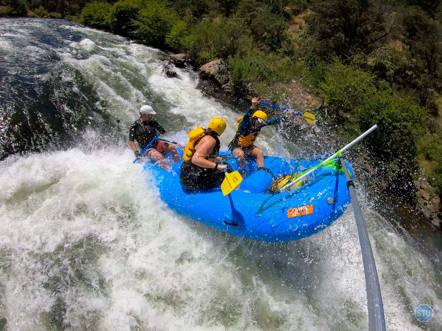
WHITEWATER RAFTING THE SOUTH FORK AMERICAN RIVER, UPPER GORGE — COLOMA, CA
The South Fork American River in Coloma, CA is one of the most popular destinations for whitewater rafting and kayaking in the country. It’s not a particularly challenging river to navigate, but it’s fairly large, accessible, with some great rapids, and a lot of cool history. This region was first inhabited by the Nisenan Indians who referred to the areas as Cullumah, meaning beautiful, but by the time gold was discovered in 1848, they were gradually pushed out by miners who flooded the valley seeking gold.
Coloma, as Elementary School History has taught us, is where John Sutter constructed a Lumber Mill, and a carpenter who worked on the mill, James W. Marshall discovered gold near the Mill’s location. The rest, of course, is history. The California Gold Rush attracted more than 300,000 prospectors all over the foothills between 1848 thru 1855 and mined more than 750,000 pounds of Gold (According to Wikipedia, Britannica, and the History Channel).
Today, the South Fork American River has become a popular destination for whitewater enthusiasts who can enjoy more than a dozen class III rapids along the 20 miles of river beginning near Placerville and finishing in Folsom Lake. The South Fork American River, Upper Gorge, is the first half of the 20-mile section beginning from Chili Bar Put In and finishing at one of the many Take Out spots in Coloma.
Miles
Ft. Descent
Classification
Route Details
River Difficulty Type: Class III
River Flows: between 1200 – 4500 CFS (Class II & III), Above 4500 CFS (Class III & IV)
Water Sources: Potable water at Chili Bar Put In, Marshall Discovery Park, and Lotus-Henningsen Park.
River Traffic: Very busy with mixed traffic (Kayakers, Commercial Rafts, Private Boaters) between May thru September and Fridays thru Sundays.
River Systems/Areas: South Fork American River, Upper Gorge, BLM (Bureau of Land Management, Central CA District)
River Awesomeness: Beautiful, isolated, scenic, and especially in the Spring when the Eastern walls of the canyon fill with California Poppies. A lot of coll history, afterall, the spot where gold was discovered in CA can be seen along this section, just after Murphy’s Bridge. And the notorious Troublemaker (III) and Meatgrinder (III) rapids are also along this section of the river.
Start Location: Chili Bar Putin In (Google Maps)
Finish Location: Lotus-Henningsen Park (Google Maps)
Fees/Permits: For Private Boating Permits, one can apply for a permit from the BLM (More info HERE). Chili Bar Put In charges $3 per vehicle and $3 per person. Lotus-Henningsen Park charges $10 per vehicle and $5 per raft. It’s recommended for boaters to bring the exact change required.
Potable Water: Yes, at Chili Bar, Discovery Park and at Lotus-Henningsen Park
Bathrooms: Yes, at Chili Bar and at Lotus-Henningsen Park, Discovery Park, and between the 2nd and 3rd threat Rapids.
Cell Reception: no, before Troublemaker. Yes, after Troublemaker.
Historical Significance: The South Fork American River is the location of Sutter’s Mill where gold was discovered in California in 1848, and initiated the California Gold Rush in 1949. Marshall Gold Discovery Park has a number of historic replicas, Museums, and monuments dedicated to the History of the California Gold Rush and the Nisenan Indians who once inhabited the area. The word Coloma comes from the Nisenan word Cullumah, meaning beautiful.
Natural Significance: The South Fork American River is one of three major rivers descending from the Sierra Nevada Mountains between I-80 and Hwy-50 that feeds Folsom Lake Reservoir, and joins with the Sacramento River in Sacramento, CA.
Attention!! On behalf of the South Fork American River whitewater community, we respectfully say to YOU the following message:
PLEASE—DO NOT raft, kayak, tube, board, swim, or attempt any portions of The South Fork American River without the guidance of an experienced whitewater guide and/or expert!!! To do so otherwise is VERY DANGEROUS! And the consequences can be MORTAL!
Route Guide
0.00 mi (1000ft) ⇒ Chili Bar & Put In | Follow the American River, South Fork to Lotus-Henningsen Park.
0.00 mi (1000ft) ⇒ Rapid: CHILI BAR HOLE (Class II) | Great little hole to surf.
0.50 mi (950ft) ⇒ Rapid: MEATGRINDER (Class III+) | Long Rapid approx ½ mile long with an Upper section, Middle Section, and Lower Section.
1.25 mi (850ft) ⇒ Rapid: RACEHORSE BEND (Class III) | Turns sharply to the left.
1.50 mi (850ft) ⇒ Rapid: MAYA (Class II) | Another great little surf hole.
2.25 mi (825ft) ⇒ Rapid: AFRICAN QUEEN (Class II) | Sometimes this one can be bigger than it looks.
2.25 mi (825ft) ⇒ Beach: Big Beach | Great spot to watch other boats blasting through African Queen.
2.50 mi (825ft) ⇒ Scenic Area:Poppy slopes | During the Spring, these exposed walls along the river-right of the Canyon fill with so many California Poppies, the slopes look gold in color.
3.25 mi (800ft) ⇒ Rapid: FIRST THREAT (Class III) | First of three big surf holes sharing the same name.
3.25 mi (800ft) ⇒ Beach: Threat Beach | Great spot to watch other boats blasting through the First Threat.
3.30 mi (800ft) ⇒ Rapid: SECOND THREAT (Class II) | The second threat is a wave train below 3500 CFS.
3.45 mi (775ft) ⇒ Beach: Lunch Beach & Restroom | Great spot to break and it includes a restroom.
3.50 mi (775ft) ⇒ Rapid: THIRD THREAT (Class III) | Last of three big surf holes sharing the same name. This one is bigger than it looks.
3.75 mi (775ft) ⇒ Rapid: FIRST & SECOND SWIMMER’S (Class II) | A series of wave trains. WARNING: very bumpy below 1300 CFS.
4.25 mi (750ft) ⇒ Island: Monkey Rock | Great spot to watch rafts passing through.
4.75 mi (750ft) ⇒ Quiet Zone Begins | No splashing or yelling as a courtesy to the local residences along this section of the river thru to Greenwood Creek, 9 miles downstream.
5.40 mi (750ft) ⇒ Rapid: TROUBLEMAKER (Class III+) | Arguably, the most technical rapid of the river. It is also a popular spot for people to hangout and watch the excitement as rafts barrel through.
5.50 mi (725ft) ⇒ Island: Spectator’s Rock | Great spot to watch rafts passing through Troublemaker.
5.90 mi (725ft) ⇒ Bridge: Mount Murphy’s Bridge | Built in 1915 to link Hwy 49 with Mt. Murphy Road.
6.00 mi (725ft) ⇒ Sutter’s Mill Site & Monument | This rock monument marks the site where Sutter’s Mill (A replica exists 100ft above this site away from the river) was constructed and gold was discovered in California on January 24, 1848.
6.25 mi (725ft) ⇒ Beach: Discovery Park Beach & Restrooms | Another spot to break and it includes restrooms.
7.25 mi (725ft) ⇒ Rapid: OLD SCARY (Class II) | Once a more difficult class III rapid before 1982 when high water diverted much of the water leftward.
7.75 mi (700ft) ⇒ Bridge: Lotus Bridge | Originally built in 1951 and re-built and updated in 2017.
8.50 mi (700ft) ⇒ Lotus-Henningsen Park & Take Out | Easy Take Out and Beach area to finish the Upper section of the South Fork American River.
RIVER FLOWS
The following river flows data for the South Fork American River has been collected, compiled, and displayed at the courtesy of DreamFlows.com.
“Thank you Chris and Dreamflows for your fantastic contribution to this exciting outdoor adventure activity!” –STOPSTU.COM
Resources
- Closest Town: Placerville, CA (10mi/10mins) and Coloma, CA (0mi/0mins) (Google Maps)
- Nearest Gas: 2 Stations near Coloma, CA (0mi/0mins) (Google Maps)
- Nearest Restaurants: Multiple near Coloma, CA (0mi/0mins) (Google Maps)
- Nearest Ranger Station: Marshall Gold Discovery Historic Park (0mi/0mins) (Google Maps)
- Rafting Companies: SEVERAL Whitewater Rafting companies near Coloma, CA (0mi/0mins) (Google Maps)
- Raft Repair: Reliable Raft Repair in Coloma, CA (0mi/0mins) (Google Maps)
- Lotus-Henningsen Park Fees
- BLM: South Fork American River info page
- CA State Parks: Marshall Gold Discovery Park website
- Recommended Whitewater Guide Schools: All-Outdoors, OARS, and American Whitewater Expeditions
- Swiftwater Rescue Courses: Sierra Rescue International
Post-Adventure EATS & BREWS
STOPSTU’s choices for EATS & BREWS near Coloma, CA.
BREWERY:
PIZZA:
SANDWICH:
BURGER:
BBQ:
CHINESE:
MEXICAN:
BREAKFAST:
COFFEE:
HEALTHY:
HONORABLE MENTIONS:
More Photos


0 Comments